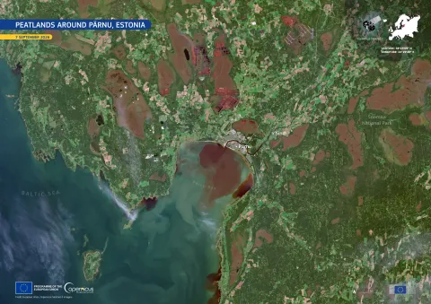
The landscape around Pärnu, Estonia, features a mix of forests, farmland, and peatlands, particularly within the Soomaa National Park. Peatlands, with their waterlogged soils, play a crucial role in carbon storage and mitigating climate change.
In the satellite image captured on September 7 by Copernicus Sentinel-2, the lush greens indicate healthy forests and farmland, whereas the brown patches represent peat bogs. The geometric reddish-brown areas indicate land that has been drained for peat extraction.
The EU Nature Restoration Regulation aims to restore drained peatlands used for agriculture. Copernicus Sentinel data aids in monitoring vegetation, water conditions, and land use, facilitating efforts in peatland restoration.