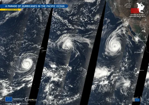
In early September 2026, a remarkable event occurred in the North Pacific Ocean: three hurricanes were simultaneously active for the first time since 2015. This phenomenon stretched over approximately 4,500 km, from west of Baja California to south of Hawaii.
-
Hurricane Lowell: The most powerful of the trio, it reached Category 5 status on September 5, boasting maximum sustained winds of 260 km/h.
-
Hurricane Karina: Positioned centrally within the group, it peaked at Category 4 with winds of 215 km/h on September 3.
-
Hurricane Marie: This hurricane formed on September 3, just before the other two hurricanes reached their peak intensity.
The Copernicus Sentinel-3 satellite captured images of these storms, showing their bright white spirals against the deep blue ocean on September 5th, from 16:29 to 22:31 UTC. The black stripes in the imagery indicate areas where satellite orbits did not overlap.
The data from Copernicus Sentinel-3 plays a crucial role in monitoring cloud structures and sea-surface conditions, thereby enhancing maritime safety, weather forecasting, and coastal risk assessments.