A Rare Trio of Tropical Cyclones in the Pacific
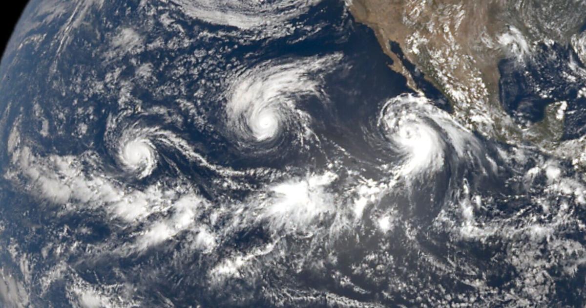
On September 2, 2026, a remarkable occurrence in the Pacific Ocean was documented by the Earth Polychromatic Imaging Camera (EPIC) aboard NOAA’s Deep Space Climate Observatory (DSCOVR) spacecraft. This rare event featured a trio of tropical cyclones, named Lowell, Karina, and Marie, dynamically interacting over the ocean.
The Cyclones’ Strengths
- Lowell: Initially predicted to reach Category 3 or 4 strength, Lowell astonishingly reached Category 5 intensity on September 2.
- Karina: Peaked at Category 4 with winds of 130 mph on September 1.
- Marie: Managed to attain only Category 2 status with a top wind speed of 100 mph.
Conditions Leading to the Cyclones
The presence of these cyclones is closely linked to El Niño, a climate pattern characterized by rising sea surface temperatures in the tropical eastern and central Pacific. These warmer waters not only provide the necessary heat and moisture but also contribute to lower air pressure, fostering the organization of thunderstorms into tropical cyclones.
Impact and Warnings
Lowell passed approximately 90 miles west of Lihue, Kauai, as a Category 2 hurricane, prompting a hurricane warning for Kauai County and a tropical storm warning for Oahu. By Tuesday morning after the formation, Lowell had weakened to 90 mph, and the forecast indicated a transition to a tropical storm, with continued concerns about flash flooding across the islands.
Historical Context
The simultaneous presence of three hurricanes is a notable event, as the last occurrence in the Eastern or Central Pacific was in 2015, involving Hurricanes Kilo, Ignacio, and Jimena during another El Niño year.
These cyclones, particularly Lowell and Karina, are salient examples of how climatic conditions can lead to extreme weather events, necessitating awareness and preparation for potentially severe impacts on communities in their path.
Source: NASA Earth Observatory via SWNS.