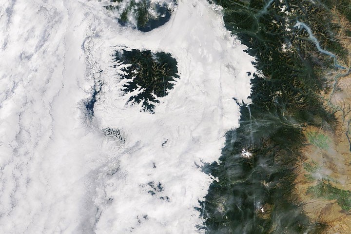
In mid-September 2026, cool marine air from the Pacific Ocean created a stunning layer of morning clouds over western Washington and Oregon. Low-lying stratus clouds and fog spread inland to the western Cascade foothills, while the taller Olympic Mountains and Oregon Coast Range emerged above this cloud cover like islands.
NASA’s MODIS (Moderate Resolution Imaging Spectroradiometer) aboard the Terra satellite captured the extensive cloud cover on September 19, 2026, around 10:45 a.m. PT (17:45 UTC). Offshore clouds were visible, along with remnants of smoke from wildfires in the North Cascades.
The National Weather Service reported several nights of onshore marine air, leading to the formation of marine stratus clouds. These clouds develop when moisture near the surface cools below the warmer air above in a temperature inversion. The cool conditions were particularly pronounced on September 19, resulting in clouds extending up to the Cascade foothills, with some areas experiencing fog where clouds touched the ground.
By the afternoon of the same day, when NASA’s Aqua satellite passed over at around 4:15 p.m. PT (23:15 UTC), many areas experienced clearer skies. However, some marine clouds lingered along the Oregon coast, where temperatures remained cooler compared to inland regions.
Image Credit
NASA Earth Observatory image by Michala Garrison, utilizing MODIS data from NASA’s EOSDIS LANCE and GIBS/Worldview.
References
- Dye, A.W., et al. (2020). Spatial patterns and trends of summertime low cloudiness for the Pacific Northwest, 1996–2017. Geophysical Research Letters, 47, e2020GL088121.
- EUMeTrain. Fog and Stratus. Accessed September 23, 2026.
- NASA Earth Observatory (2016). A Celebration of Clouds From Space, Earth Has an Elegant Atmosphere. Accessed September 23, 2026.
- National Weather Service. What are Marine Layer Clouds and How Do they Form?. Accessed September 23, 2026.
- National Weather Service Portland, OR (2026). Area Forecast Discussion. Accessed September 23, 2026.
- National Weather Service Seattle, WA (2026). Area Forecast Discussion. Accessed September 23, 2026.